Private territory mapping: Difference between revisions
No edit summary |
|||
| (53 intermediate revisions by the same user not shown) | |||
| Line 1: | Line 1: | ||
TERRITORY_MAPPING | |||
<br/> | <br/> | ||
<br/> | <br/> | ||
This protocol records breeding birds in a defined territory area. '''The interface to enter data in the context of | This protocol records breeding birds in a defined territory area. '''The interface to enter data in the context of Private territory mapping protocol exists only for NaturaList''', but it can be edited and viewed through the web (after synchronisation). Go to Mobile interface > Protocols > [[Private_territory_mapping_(NL)|Private territory mapping]] to see how to enter data. <br/> | ||
<br/> | <br/> | ||
Access your protocol from Menu > Take part > All my protocol > Private territory mapping. <br/> | Access your protocol from Menu > Take part > All my protocol > Private territory mapping. <br/> | ||
For other options, visit wiki section Web interface > Local portal > Protocols > [[Protocols_web#Accessing_protocols|Accessing protocols]]. <br/> | |||
<br/> | <br/> | ||
<center> | <center> | ||
<div class="toc" style="border-radius:5px;background-color:#ffffff;padding-left:8px;padding-right:8px;padding-bottom:8px;width:400px;"> | <div class="toc" style="border-radius:5px;background-color:#ffffff;padding-left:8px;padding-right:8px;padding-bottom:8px;width:400px;"> | ||
[[File:PTM Menu.png|400px]] | [[File:PTM Menu.png|400px|link=https://help.biolovision.net/images/7/71/PTM_Menu.png]] | ||
<div class="toc" style="border-radius:5px;padding-left:15px;text-align:left; font-size:12px;width:385px;"> | <div class="toc" style="border-radius:5px;padding-left:15px;text-align:left; font-size:12px;width:385px;"> | ||
'''Private territory mapping. Menu.''' | '''Private territory mapping. Menu.''' | ||
| Line 22: | Line 23: | ||
<div class="toc" style="width:350px;"> <!-- La llargada s'ha de canviar aquí --> | <div class="toc" style="width:350px;"> <!-- La llargada s'ha de canviar aquí --> | ||
<div class="mw-collapsible mw-collapsed" data-expandtext="Show" data-collapsetext="Hide" style="width:300px;margin-bottom:0px;margin-top:0px;background-color:#f7f7f7;"> | <div class="mw-collapsible mw-collapsed" data-expandtext="Show" data-collapsetext="Hide" style="width:300px;margin-bottom:0px;margin-top:0px;background-color:#f7f7f7;"> | ||
''' | '''Private territory mapping''' | ||
<div class="mw-collapsible-content" style="width:350px;background-color:#f7f7f7;"> <!-- I també cal canviar la llargada aquí --> | <div class="mw-collapsible-content" style="width:350px;background-color:#f7f7f7;"> <!-- I també cal canviar la llargada aquí --> | ||
<ol> | <ol> | ||
1 [[Private territory mapping#Preparation_and_data|Preparation and data]] <br /> | |||
<ol> | <ol>1.1 [[Private_territory_mapping_(NL)#Entering_records|Add observations (in NaturaList)]]<br/> | ||
1.2 [[Private territory mapping#Results|Results]]<br/> | |||
1.3 [[Private territory mapping#Display_on_map|Display on map]]<br/> | |||
1.4 [[Private territory mapping#Modify_the_protocol|Modify the protocol]]<br/> | |||
1.5 [[Private territory mapping#Census_results|Census results]]<br/> | |||
<ol> | <ol>1.5.1 [[Private territory mapping#Protocol_section|Protocol section]]<br/> | ||
1.5.2 [[Private territory mapping#Observations_section|Observations section]]<br/></ol></ol></ol> | |||
<ol><ol> | <ol><ol> 1.6 [[Private territory mapping#Download_map|Download map]]</ol></ol> | ||
<ol> | <ol> 2 [[Private territory mapping#Check_data|Check data]]<br/> | ||
3 [[Private territory mapping#Map|Map]]<br/> </ol> | |||
</div> | </div> | ||
</div> | </div> | ||
| Line 43: | Line 44: | ||
<span id="Preparation_and_data"></span> | <span id="Preparation_and_data"></span> | ||
== | ==TERRITORY MAPPING Preparation and data== | ||
<br/> | <br/> | ||
<center> | <center> | ||
<div class="toc" style="border-radius:5px;background-color:#ffffff;padding-left:8px;padding-right:8px;padding-bottom:8px;width:400px;"> | <div class="toc" style="border-radius:5px;background-color:#ffffff;padding-left:8px;padding-right:8px;padding-bottom:8px;width:400px;"> | ||
[[File:PTM Prep and data.png|400px]] | [[File:PTM Prep and data.png|400px|link=https://help.biolovision.net/images/a/a1/PTM_Prep_and_data.png]] | ||
<div class="toc" style="border-radius:5px;padding-left:15px;text-align:left; font-size:12px;width:385px;"> | <div class="toc" style="border-radius:5px;padding-left:15px;text-align:left; font-size:12px;width:385px;"> | ||
'''Private territory mapping. Preparation and data.''' | '''Private territory mapping. Preparation and data.''' | ||
| Line 57: | Line 58: | ||
<br/> | <br/> | ||
Lists all sites available to the current user and allows downloading printable maps and viewing results. Data can only be entered through NaturaList. Visit wiki section mobile interface > Protocols > [[Private_territory_mapping_(NL)|Private territory mapping]] to know how to enter data in the Private territory mapping protocol.<br/> | |||
Lists all sites available to the current user and allows downloading printable maps and viewing results. Data can only be entered through NaturaList. Visit [[ | |||
<br/> | <br/> | ||
<div class="toc" style="width:300px;"> <!-- La llargada s'ha de canviar aquí --> | <div class="toc" style="width:300px;"> <!-- La llargada s'ha de canviar aquí --> | ||
<div class="mw-collapsible mw-collapsed" data-expandtext="Show" data-collapsetext="Hide" style="width:300px;margin-bottom:0px;margin-top:0px;background-color:#f7f7f7;"> | <div class="mw-collapsible mw-collapsed" data-expandtext="Show" data-collapsetext="Hide" style="width:300px;margin-bottom:0px;margin-top:0px;background-color:#f7f7f7;"> | ||
''' | '''1 Preparation and data''' | ||
<div class="mw-collapsible-content" style="width:300px;background-color:#f7f7f7;"> <!-- I també cal canviar la llargada aquí --> | <div class="mw-collapsible-content" style="width:300px;background-color:#f7f7f7;"> <!-- I també cal canviar la llargada aquí --> | ||
<ol> | <ol>1.1 [[Private_territory_mapping_(NL)#Entering_records|Add observations (in NaturaList)]]<br/> | ||
1.2 [[Private territory mapping#Results|Results]]<br/> | |||
1.3 [[Private territory mapping#Display_on_map|Display on map]]<br/> | |||
1.4 [[Private territory mapping#Modify_the_protocol|Modify the protocol]]<br/> | |||
1.5 [[Private territory mapping#Census_results|Census results]]<br/> | |||
<ol> | <ol> 1.5.1 [[Private territory mapping#Protocol_section|Protocol section]]<br/> | ||
1.5.2 [[Private territory mapping#Observations_section|Observations section]]<br/></ol></ol> | |||
<ol> | <ol> 1.6 [[Private territory mapping#Download_map|Download map]]</ol> | ||
</div> | </div> | ||
</div> | </div> | ||
| Line 81: | Line 79: | ||
<span id="Results"></span> | <span id="Results"></span> | ||
=== | ===TERRITORY MAPPING Results=== | ||
<br/> | <br/> | ||
[[File:PTM Results.png|700px| | <center> | ||
<div class="toc" style="border-radius:5px;background-color:#ffffff;padding-left:8px;padding-right:8px;padding-bottom:8px;width:700px;"> | |||
[[File:PTM Results.png|700px|link=https://help.biolovision.net/images/5/59/PTM_Results.png]] | |||
<div class="toc" style="border-radius:5px;padding-left:15px;text-align:left; font-size:12px;width:685px;"> | |||
'''Private territory mapping. Results.''' | |||
</div> | |||
</div> | |||
</center> | |||
<br/> | |||
<br/> | <br/> | ||
| Line 91: | Line 97: | ||
Visit wiki section Web interface > Protocols > Preparation and data > [[Protocols_web#Results|Results]] for details. <br/> | Visit wiki section Web interface > Protocols > Preparation and data > [[Protocols_web#Results|Results]] for details. <br/> | ||
<br/> | |||
[[Private territory mapping#Preparation and data|[Top to Preparation and data]]] <br/> | |||
[[#top|[Back to Private territory mapping protocol]]]<br/> | |||
<br/> | <br/> | ||
<span id="Display on map"></span> | <span id="Display on map"></span> | ||
=== | ===TERRITORY MAPPING Display on map=== | ||
<br/> | <br/> | ||
[[File:PTM Display on map.png|700px| | <center> | ||
<div class="toc" style="border-radius:5px;background-color:#ffffff;padding-left:8px;padding-right:8px;padding-bottom:8px;width:700px;"> | |||
[[File:PTM Display on map.png|700px|link=https://help.biolovision.net/images/3/33/PTM_Display_on_map.png]] | |||
<div class="toc" style="border-radius:5px;padding-left:15px;text-align:left; font-size:12px;width:685px;"> | |||
'''Private territory mapping. Display on map.''' | |||
</div> | |||
</div> | |||
</center> | |||
<br/> | |||
<br/> | <br/> | ||
| Line 105: | Line 123: | ||
Visit wiki section Web interface > Protocols > Preparation and data > [[Protocols_web#Display_on_map|Display on map]] for details. <br/> | Visit wiki section Web interface > Protocols > Preparation and data > [[Protocols_web#Display_on_map|Display on map]] for details. <br/> | ||
<br/> | |||
[[Private territory mapping#Preparation and data|[Top to Preparation and data]]] <br/> | |||
[[#top|[Back to Private territory mapping protocol]]]<br/> | |||
<br/> | <br/> | ||
<span id="Modify the protocol"></span> | <span id="Modify the protocol"></span> | ||
=== | |||
===TERRITORY MAPPING Modify the protocol=== | |||
<br/> | <br/> | ||
[[File:PTM Modify the protocol.png|700px| | <center> | ||
<div class="toc" style="border-radius:5px;background-color:#ffffff;padding-left:8px;padding-right:8px;padding-bottom:8px;width:700px;"> | |||
[[File:PTM Modify the protocol.png|700px|link=https://help.biolovision.net/images/d/d7/PTM_Modify_the_protocol.png]] | |||
<div class="toc" style="border-radius:5px;padding-left:15px;text-align:left; font-size:12px;width:685px;"> | |||
'''Private territory mapping. Modify the protocol.''' | |||
</div> | |||
</div> | |||
</center> | |||
<br/> | |||
<br/> | <br/> | ||
| Line 118: | Line 149: | ||
Visit wiki section Web interface > Protocols > Preparation and data > [[Protocols_web#Modify_the_protocol|Modify the protocol]] for details. <br/> | Visit wiki section Web interface > Protocols > Preparation and data > [[Protocols_web#Modify_the_protocol|Modify the protocol]] for details. <br/> | ||
<br/> | |||
[[Private territory mapping#Preparation and data|[Top to Preparation and data]]] <br/> | |||
[[#top|[Back to Private territory mapping protocol]]]<br/> | |||
<br/> | <br/> | ||
<span id="Census results"></span> | <span id="Census results"></span> | ||
=== | |||
===TERRITORY MAPPING Census results=== | |||
<br/> | <br/> | ||
[[File:PTM Census results.png|700px| | <center> | ||
<div class="toc" style="border-radius:5px;background-color:#ffffff;padding-left:8px;padding-right:8px;padding-bottom:8px;width:700px;"> | |||
[[File:PTM Census results.png|700px|link=https://help.biolovision.net/images/f/f1/PTM_Census_results.png]] | |||
<div class="toc" style="border-radius:5px;padding-left:15px;text-align:left; font-size:12px;width:685px;"> | |||
'''Private territory mapping. Census results.''' | |||
</div> | |||
</div> | |||
</center> | |||
<br/> | |||
<br/> | <br/> | ||
| Line 134: | Line 178: | ||
<span id="Protocol section"></span> | <span id="Protocol section"></span> | ||
==== | ====TERRITORY MAPPING Protocol section==== | ||
<br/> | <br/> | ||
| Line 144: | Line 188: | ||
<span id="Observations section"></span> | <span id="Observations section"></span> | ||
==== | ====TERRITORY MAPPING Observations section==== | ||
<br/> | <br/> | ||
| Line 156: | Line 200: | ||
<br/> | <br/> | ||
[[File:2023-09-12 PTM local portal relationship btw indv.png| | <center> | ||
<div class="toc" style="border-radius:5px;background-color:#ffffff;padding-left:8px;padding-right:8px;padding-bottom:8px;width:400px;"> | |||
[[File:2023-09-12 PTM local portal relationship btw indv.png|400px|link=https://help.biolovision.net/images/7/75/2023-09-12_PTM_local_portal_relationship_btw_indv.png]] | |||
<div class="toc" style="border-radius:5px;padding-left:15px;text-align:left; font-size:12px;width:385px;"> | |||
'''Visualising relationship between individuals in Local portal''' | |||
</div> | |||
</div> | |||
</center> | |||
<br/> | |||
<br/> | <br/> | ||
| Line 167: | Line 219: | ||
<br /> | <br /> | ||
[[File: | <center> | ||
<div class="toc" style="border-radius:5px;background-color:#ffffff;padding-left:8px;padding-right:8px;padding-bottom:8px;width:600px;"> | |||
::: | [[File:add info on maps.png|600 px|link=https://help.biolovision.net/images/b/b0/Add_info_on_maps.png]] | ||
<div class="toc" style="border-radius:5px;padding-left:15px;text-align:left; font-size:12px;width:585px;"> | |||
'''Add or modify additional information on local portal.''' | |||
</div> | |||
<p style="color:black;font-size:12px;padding-left:5px;text-align:left;column-count:1;padding-right:5px;"> | |||
'''1. Individuals of the same species:''' Select/deselect all individuals of the same species, and show their details. If a relationship between the sightings have been recorded, it will be shown/hidden here. <br/> | |||
'''2. Flight direction:''' Modify flight direction if necessary. To add/modify flight direction,<br/> | |||
-click on the arrow icon, <br/> | |||
-select the individual you want to add flight direction to (it becomes red), <br/> | |||
-move the mouse to match the blue round (top) to the flight direction (bottom). See [[Media:Adding flight direction on the web.png|example]]. <br/> | |||
'''3. Flight direction:''' Circle flight. <br/> | |||
'''4. Access record:''' Access record details including information about the list and other species from the same list, as if from Home > Main menu (left column) > [[Browsing_records#All_my_observations|All my observations]]. The individual the function applies to is indicated by a | |||
[[Media:2023-09-20 ind selected to edit.png|blue circle around it]].<br/> | |||
'''5. Delete:''' Delete the selected record. You will be prompted to confirm. <br/> | |||
</p> | |||
</div> | |||
</center> | |||
<br/> | <br/> | ||
<br/> | <br/> | ||
[[Private territory mapping#Preparation and data|[Top to Preparation and data]]] <br/> | |||
[[#top|[Back to Private territory mapping protocol]]]<br/> | |||
<br/> | <br/> | ||
<span id="Download map"></span> | |||
===TERRITORY MAPPING Download map=== | |||
<br/> | <br/> | ||
< | <center> | ||
<div class="toc" style="border-radius:5px;background-color:#ffffff;padding-left:8px;padding-right:8px;padding-bottom:8px;width:700px;"> | |||
[[File:PTM Download map..png|700px|link=https://help.biolovision.net/images/1/1f/PTM_Download_map..png]] | |||
<div class="toc" style="border-radius:5px;padding-left:15px;text-align:left; font-size:12px;width:685px;"> | |||
'''Private territory mapping. Download map.''' | |||
</div> | |||
</div> | |||
</center> | |||
<br/> | <br/> | ||
<br/> | <br/> | ||
| Line 196: | Line 265: | ||
Visit wiki section Web interface > Protocols > Preparation and data > [[Protocols_web#Download_map|Download map]] for details. <br/> | Visit wiki section Web interface > Protocols > Preparation and data > [[Protocols_web#Download_map|Download map]] for details. <br/> | ||
<br/> | |||
[[Private territory mapping#Preparation and data|[Top to Preparation and data]]] <br/> | |||
[[#top|[Back to Private territory mapping protocol]]]<br/> | |||
<br/> | <br/> | ||
<span id="Check data"></span> | <span id="Check data"></span> | ||
== | ==TERRITORY MAPPING Check data== | ||
<br/> | <br/> | ||
[[File:PTM Check data.png| | <center> | ||
<div class="toc" style="border-radius:5px;background-color:#ffffff;padding-left:8px;padding-right:8px;padding-bottom:8px;width:300px;"> | |||
[[File:PTM Check data.png|300px|link=https://help.biolovision.net/images/1/1d/PTM_Check_data.png]] | |||
<div class="toc" style="border-radius:5px;padding-left:15px;text-align:left; font-size:12px;width:285px;"> | |||
'''Private territory mapping. Check data.''' | |||
</div> | |||
</div> | |||
</center> | |||
<br/> | |||
<br/> | <br/> | ||
| Line 210: | Line 291: | ||
Visit wiki section Web interface > Protocols > Preparation and data > [[Protocols_web#Check_data|Check data]] for details. <br/> | Visit wiki section Web interface > Protocols > Preparation and data > [[Protocols_web#Check_data|Check data]] for details. <br/> | ||
<br/> | |||
[[Private territory mapping#Check data|[Top to Check data]]] <br/> | |||
[[#top|[Back to Private territory mapping protocol]]]<br/> | |||
<br/> | <br/> | ||
<span id="Map"></span> | <span id="Map"></span> | ||
== | |||
==TERRITORY MAPPING Map== | |||
<br/> | <br/> | ||
[[File:PTM Map.png| | <center> | ||
<div class="toc" style="border-radius:5px;background-color:#ffffff;padding-left:8px;padding-right:8px;padding-bottom:8px;width:300px;"> | |||
[[File:PTM Map.png|300px|link=https://help.biolovision.net/images/9/9c/PTM_Map.png]] | |||
<div class="toc" style="border-radius:5px;padding-left:15px;text-align:left; font-size:12px;width:285px;"> | |||
'''Private territory mapping. Map.''' | |||
</div> | |||
</div> | |||
</center> | |||
<br/> | |||
<br/> | <br/> | ||
| Line 225: | Line 319: | ||
<br/> | <br/> | ||
[[Private territory mapping#Map|[Top to Map]]] <br/> | |||
[[#top|[Top to Private territory mapping]]]<br/> | [[#top|[Top to Private territory mapping]]]<br/> | ||
[[Protocols_web|[Back to Protocols]]]<br/> | [[Protocols_web|[Back to Protocols]]]<br/> | ||
<br/> | <br/> | ||
Latest revision as of 15:49, 13 February 2026
TERRITORY_MAPPING
This protocol records breeding birds in a defined territory area. The interface to enter data in the context of Private territory mapping protocol exists only for NaturaList, but it can be edited and viewed through the web (after synchronisation). Go to Mobile interface > Protocols > Private territory mapping to see how to enter data.
Access your protocol from Menu > Take part > All my protocol > Private territory mapping.
For other options, visit wiki section Web interface > Local portal > Protocols > Accessing protocols.
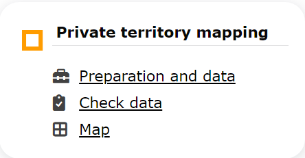
Private territory mapping. Menu.
Private territory mapping
-
1 Preparation and data
- 1.1 Add observations (in NaturaList)
1.2 Results
1.3 Display on map
1.4 Modify the protocol
1.5 Census results
- 1.5.1 Protocol section
1.5.2 Observations section
- 1.6 Download map
- 2 Check data
3 Map
TERRITORY MAPPING Preparation and data
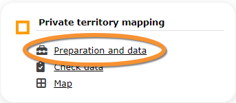
Private territory mapping. Preparation and data.
Lists all sites available to the current user and allows downloading printable maps and viewing results. Data can only be entered through NaturaList. Visit wiki section mobile interface > Protocols > Private territory mapping to know how to enter data in the Private territory mapping protocol.
1 Preparation and data
- 1.1 Add observations (in NaturaList)
1.2 Results
1.3 Display on map
1.4 Modify the protocol
1.5 Census results
- 1.5.1 Protocol section
1.5.2 Observations section
- 1.6 Download map
TERRITORY MAPPING Results

Private territory mapping. Results.
See some statistics about your surveys results.
Visit wiki section Web interface > Protocols > Preparation and data > Results for details.
[Top to Preparation and data]
[Back to Private territory mapping protocol]
TERRITORY MAPPING Display on map
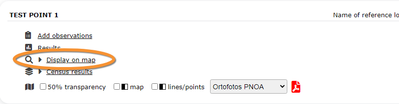
Private territory mapping. Display on map.
For the selected site, see the area to survey on a map. To know how to navigate the map, refer to wiki section Web interface > Navigating the map.
Visit wiki section Web interface > Protocols > Preparation and data > Display on map for details.
[Top to Preparation and data]
[Back to Private territory mapping protocol]
TERRITORY MAPPING Modify the protocol
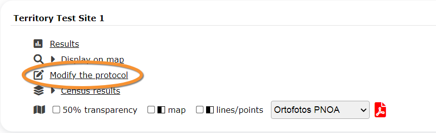
Private territory mapping. Modify the protocol.
Modify the site to survey.
Visit wiki section Web interface > Protocols > Preparation and data > Modify the protocol for details.
[Top to Preparation and data]
[Back to Private territory mapping protocol]
TERRITORY MAPPING Census results
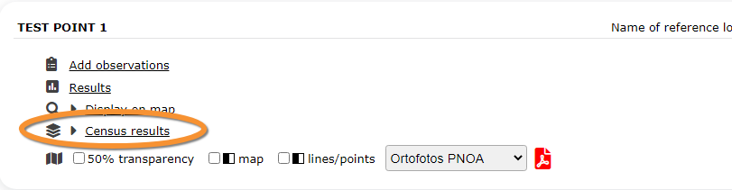
Private territory mapping. Census results.
Click on Census results to see all available years with data for this site (see image Protocol. Selecting year to visualise). Select the one to visualise.
Visit wiki section Web interface > Protocols > Preparation and data > Census results for details.
TERRITORY MAPPING Protocol section
General information about the selected visit at the selected site.
Visit wiki section Web interface > Protocols > Preparation and data > Census results > Protocol section for details.
TERRITORY MAPPING Observations section
Summary of observations at the selected site.
Visit wiki section Web interface > Protocols > Preparation and data > Census results > Observations section for details.
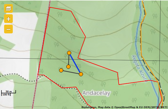
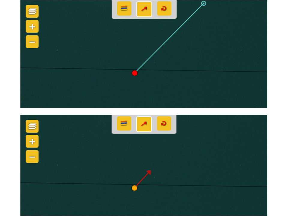
When flying direction or relationship between individuals were introduced while recording observations in NaturaList, details can be visualised in this section (see example below).
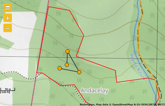
Visualising relationship between individuals in Local portal
Click on the lines to show its colour: green indicates same individual, orange is unknown and blue confirms different individuals.
Click on any record to see details and/or edit.
The button below appears and you can use it to correct your data:
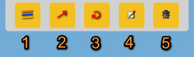
Add or modify additional information on local portal.
1. Individuals of the same species: Select/deselect all individuals of the same species, and show their details. If a relationship between the sightings have been recorded, it will be shown/hidden here.
2. Flight direction: Modify flight direction if necessary. To add/modify flight direction,
-click on the arrow icon,
-select the individual you want to add flight direction to (it becomes red),
-move the mouse to match the blue round (top) to the flight direction (bottom). See example.
3. Flight direction: Circle flight.
4. Access record: Access record details including information about the list and other species from the same list, as if from Home > Main menu (left column) > All my observations. The individual the function applies to is indicated by a
blue circle around it.
5. Delete: Delete the selected record. You will be prompted to confirm.
[Top to Preparation and data]
[Back to Private territory mapping protocol]
TERRITORY MAPPING Download map
Private territory mapping. Download map.
Download maps ready to print.
Visit wiki section Web interface > Protocols > Preparation and data > Download map for details.
[Top to Preparation and data]
[Back to Private territory mapping protocol]
TERRITORY MAPPING Check data

Private territory mapping. Check data.
Calendar showing visits to different sites and number of species detected.
Visit wiki section Web interface > Protocols > Preparation and data > Check data for details.
[Top to Check data]
[Back to Private territory mapping protocol]
TERRITORY MAPPING Map
Private territory mapping. Map.
Map and statistics for site.
Visit wiki section Web interface > Protocols > Preparation and data > Map for details.
[Top to Map]
[Top to Private territory mapping]
[Back to Protocols]